Written by Catherine Serrant, Research Assistant, National Trust of Trinidad and Tobago
In the distance a tall tower looms. Its merciless beam pierces any fog and the seas mists are no match for it. Wave after wave tries to dislodge it from its pedestal, but this was made to stand the test of water and of time.
Who am I? A lighthouse!
Lighthouses are an essential part of coastal and island living. Seafarers need guidance when traversing the shoreline and deep waters in order to get on, off and around the island safely. Why a blog about lighthouses? Because #MonumentsMatter, and what’s more exciting than a beacon you can see both in the day and at night? When out and about in the country, you pass them all the time. This blog offers a great way to start building on your current knowledge of Trinidad’s majestic monuments. We’ll be taking a look at the Northern Lighthouses in Trinidad- the Brigand Hill, Chacachacare, Toco and St. Vincent Jetty Lighthouses. Plus, there’ll be a bonus mystery lighthouse at the end!
Brigand Hill Lighthouse
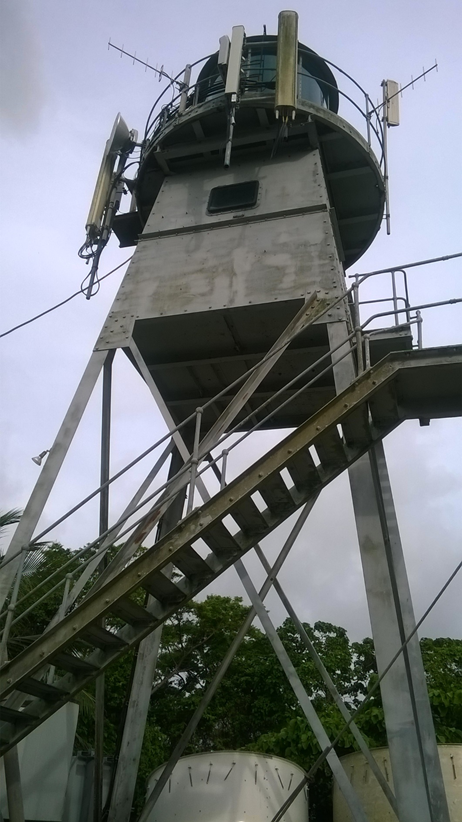
The Brigand Hill Lighthouse was constructed in 1958 at Plum Mitan Road in Manzanilla. It has a latitude of 10.29m.37s and a longitude 61 04 14 West, with an elevation of 270m above sea level. Its tower is approximately 60ft. This all-metal structure features a dome at the top, with the (guide) light in the middle. The staircase on the outside of is also metal. Cellular signal antennas are a recent addition. This light works and has a range of 20 nautical miles using an Electronic Control Module (ECM) unit. Presently it operates at a range of 18NM. Its character is White flash – 2 flashes- pause- 1 flash (so that the Flash code is (2+1) W 30 seconds.) Electrical power (24 Volts) with the use of batteries keeps the light going 24 hours a day. Sea Blast from the Manzanilla Beach, to the east of the lighthouse is the main element that degrades the metal structure. It is important to note that the lighthouse has living quarters, for the post to be manned.
Did you know? Brigand Hill, is linked to our African history and maroon heritage in Manzanilla. Our website will have these engrossing details, be sure to have a read when you finish this blog.

Brigand Hill Lighthouse.
Source: Maritime Services Division, Ministry of Works and Transport.
Source: National Trust
Chacachacare “Bocas” Lighthouse
Constructed in 1897 (because Queen Victoria was doing the most during her Jubilee celebrations) on the island of Chacachacare, its latitude is 10.41.49 and the longitude is 61 45m 15s.The light had a range of 23NM, but was reduced to 18 NM. The tower’s height is approximately 65-70ft with an elevation of 251m above sea level. The dome is located at the top with a 24 volt light that emits a white flash every 10 seconds in the middle. Cellular signal antennas are present on the outside of the structure while inside there is a spiral metal staircase that takes climbers to the top of the building.
#DDI is the place to be, to see the Bocas Lighthouse. Ooh-la-la, there’s wind in your hair and the sun is on your face. Lovely for you but no so fun for the Lighthouse itself. That sea blast is a beast let me tell you! Added to that is the constant buffering from the NE Trade winds. These harsh weather conditions (inclusive of hurricanes when they do pass by) are the main factors affecting the structure. This is meant to be a manned post, but is currently unmanned, as there are no facilities in place to allow a person to stay. Unfortunately the light is not functioning at present. The Maritime Services Division #MSD is in process of acquiring a battery charger (for one of the components of its primary energy supply), though it can be fully powered by generators. After the Installation of the new batteries, the MSD hopes to have this Lighthouse up by the earliest possible date.

MSD Photo of the Chacachacare Lighthouse.
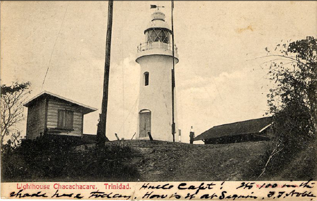
UWI’s Michael Goldberg Collection. Post card of the “Chacachacare Lighthouse, Trinidad”
St. Vincent Jetty Lighthouse
This is the star of those “Beyond the Lighthouse” jokes many “West people” love to make! Our capital city is home to an oldie but a goldie– the St. Vincent jetty Lighthouse which was erected in 1842. This monument was built during the early years of Queens Victoria’s reign. (I know you’ve already taken note of her name, and yes- it will pop up again, for another monument. *wink*) Constructed by Governor Colonel Sir Henry McLeod in the Port of Spain Harbour, it assisted in controlling sea traffic by guiding the entry and exit of ships. Let’s rewind, to the time when Broadway- off Independence Square- was called Almond Walk, and then go further back in time, to when that area was part of Marine Square. Known as Plaza del Marina under Spanish Governor Chacon, plans were made to extend this Square southwards, with Lots becoming available for rent. The first reclamation of the land was in 1803 under British Governor Picton, with these Sea Lots being filled in by their owners, who also had to contribute to the construction of the roadway. The second reclamation occurred in 1845, where the area of the jetty (on St. Vincent Street) and mole[1] became part of the land.[2] This structure was a main feature of the Port of Spain harbour, with the Customs House to the front and the jetty extending into the Gulf of Paria.
Today, the St. Vincent jetty lighthouse is landlocked.

UWI’s Michael Goldberg Collection. Postcards of the “Lighthouse Jetty Trinidad BWI”.
You all remember this one from the recent All About Toco Blog. Its actual name is The Galera Point Lighthouse, and it was constructed in 1897. Quick note- it has not been changed to the Keshorn Walcott Lighthouse as planned, because it is not a simple matter to change a Lighthouse’s name. This particular lighthouse was an essential feature on the north easterly coast, because regular overland passage for motor vehicles was not established until the 1930s. Let’s name the coastal villages being serviced on this sea route: Toco, Cumana, Grande Riviere, Blanchisseuse and Matelot. (Good job, you remembered them, yay!) This Lighthouse also functioned to regulate traffic from a round-the-island coastal Steamer service. As Trini’s say, “knowing full well” how uneven development in Trinidad is, with primary focus being given to the western side of the island, the establishment of the Galera Point Lighthouse was a #MajorMilestone (Mohammed, 2009)[3]” for the east coast, when it opened on November 1st in the year of Queen Victoria’s Golden Jubilee! (Third time’s the charm; talk about a colonial legacy, right?) This aspect of our island’s development currently serves as an historic landmark and navigational aid. What upgrades has it undergone? The typical ones that come with advances in technology. Its original barrel-shaped lantern was replaced in the later part of the 1950s, by an automatic blinking light with a white flash of 10 seconds, occulting. It has the tallest of the three towers standing at 80ft and its light has a range of 16NM reduced to 14, and the lighthouse compound is currently being upgraded by the Ministry of Tourism, Culture and the Arts and is closed to the public at this time. Keep your eyes on The Ministry’s website for the re-opening date.

UWI Michael Goldbery Collection. Postcard of “Point Galera, Trinidad”
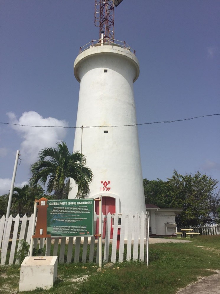
Photo of the Galera Point Lighthouse, Toco. By: Kara Roopsingh.
Icacos Lighthouse
Ready for a mystery? *cue eerie music* Trying to solve “The Case of the Disappearing Lighthouse” is sure to keep you awake all night. At Corral Point in Icacos, there once existed a Lighthouse along the shoreline of Constance Estate (a major coconut oil production area).
“Once existed, but… but Catherine, where it gone, how yuh mean once existed?”
Environmental group For the love of the environment reports that only the base of the lighthouse remains, sitting on the actual seabed some 25ft under the surf. It is approximately 200m from the end of the road. The photo of the original structure was taken 55 years ago, when the lighthouse was still on land.
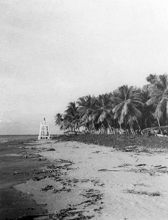
The sole clue about the disappearing lighthouse. Source: For love of the environment Facebook page
There is no shortage of rich built heritage within our twin islands. Lighthouses provide safety and security for voyagers in the Caribbean Sea and Gulf of Paria. They were a major part of the process of ship guiding- for voyages that brought our ancestors here, for ships that would make or break the fortunes of our forefathers. Their duty of giving warning and assisting in navigation continues to the present. For Trinidad, they mark stages of improvement and progress towards greater levels of development in our sea-transportation trade and industry.
Here at the National Trust, we wish to extend a heartfelt thank you to the Superintendent of Lighthouses Mr. Ralph Boland and to the Ministry of Tourism, Culture and the Arts for their assistance which made the research possible! Collaboration is what we’re about in 2021. I’m definitely loving the National Trust x MSD x Ministry of Tourism vibe. Who would like the Trust to do a Lighthouses Trust Tour later this year? (Of course, bear in mind this would only be possible if the upgrades are completed and they are re-opened and tours are once again available, omg!) I can’t wait to take a trip and see the built heritage that I’ve been writing about!
Author: Catherine Serrant
Sources
Besson, Gerard. The Reclamation of land at ‘Conquerabia’ and the lighthouse. https://caribbeanhistoryarchives.blogspot.com/search?q=st+vincent+jetty+lighthouse
Emancipation Special, Manzanilla. CNC3 Television, Trinidad and Tobago. https://www.facebook.com/CNC3Television/videos/10153511817487996/UzpfSTQxOTg5MDk4MTM3ODUwMToxMDUyNDkyNTI4MTE4MzQw/
Interview with the Superintendent of Lighthouses (Acting) Ralph Boland of the Maritime Services Division of the Ministry of Works and Transport on 30th October 2020.
Photo of the Icacos Lighhouse at Constance Estate. https://www.facebook.com/For-love-of-the-environment-1022242818163637/photos/pcb.1579642299090350/1579637005757546/
University of the West Indies, St Augustine Campus. The Alma Jordan Library’s Digital Collection. Special Collection. Michael Goldberg Collection. 2009
Chacachacare http://hdl.handle.net/2139/6200
St Vincent Jetty http://hdl.handle.net/2139/9319
Galera Point http://hdl.handle.net/2139/4388
[1] A mole is a massive structure, usually of stone, used as a pier, breakwater, or a causeway between places separated by water. A mole may have a wooden structure built on top of it that resembles a wooden pier. The defining feature of a mole, however, is that water cannot freely flow underneath it, unlike a true pier.
[2] Besson, Gerard. “The Reclamation of land at ‘Conquerabia’ and the lighthouse.”
[3] Mohammed, “La Foret”.