Climb aboard the #TT_History_Bus, let’s journey through time to explore four Forts of Port of Spain! Before we dive in, when we say Port of Spain, we’re not using the modern-day City Corporation boundaries. POS only became the capital of Trinidad in 1757, and so the forts would have been placed to strategically defend the 18th century version of the city. In the 1780s the Ward of POS is massive! This barrio (the Spanish term for ward, because we were still a Spanish colony) included what we now know as the St. Ann’s hills, The Dry River (and accompanying hilled villages) Independence Sq, (Downtown, the OG fishing village settlement) the whole Foreshore (and accompanying villages like Woodbrook St. James, Newtown) all the way back to Mucurapo.
Now our #Forts are some of the oldest constructed colonial buildings in our nation. A Fort, for the purposes of this blog, refers to a military building or a strategic position, whose original purpose was security and protection. Any colonial power worth their salt must be able to secure the citizens from outside threats while protecting their wealth and people of the island successfully. Forts in particular represent such a crucial period in Trinidad’s history as they provide a cross sectional look at various periods of our colonial development.

#TT_History_Bus, taking our mind places!
A little preamble for context: Trinidad was claimed in 1498 and placed under Spanish colonial rule. When explorers realized Trinidad had no gold (El Dorado, NOTHING!), we crept along with very slow agricultural development. Spain struggled to develop her island colonies, in comparison to her mainland ones (Spence, 2014). The primary sources of supplies came from the mainland or black market trading and piracy. So even though the Spanish were in charge, settlers would do trade with non-Spanish nationals. Also note that Trinidad was home to non-Spanish nationals, primarily because of her strategic location as a steppingstone to South America. It made sense to have a foothold in and on Trinidad. Imagine, Governor Jose Maria Chacon (for whom our national flower is named) was in charge and then on February 18th 1797 Admiral Ralph Abercromby (for whom Abercromby St in POS is named) took over. Can you get whiplash from such a speedy Capitulation[1]? In classic melting pot stylings: The Spanish got booted out of government and the British were in. Note that Spanish civil laws were kept in place until 1834 (Ottley, 1962) but we also had a bunch of French nationals residing here, as well as the Africans who were a combination of enslaved people or freed people of colour. Along with these groups were the First Peoples and finally Irish and Portuguese folks. So how many different nationalities (with their varied ideas) were trying to co-exist in one space? Keep reading and I’ll show you how Forts are related to all of this.
Fort San Andres, downtown Port of Spain
Hint: Spain, wanting to defend her colonial jewel, encouraged this construction.

Ohh and ahh with me at the mini almost moat around the fort wall.
Channelling that ‘Last Badjohn of Spanish rule’ vibe is the now land locked Fort San Andres, opposite City Gate. Once a Museum of the City of Port of Spain this is the “last surviving fortification from the period of Spanish occupation” (Besson, 2012) which is tangible evidence of our Spanish colonial heritage. In 1733 this would have been the edge of the Gulf of Paria. Initially there was temporary military shelter (called a redoubt/ redout) placed on a fascine (which is a pathway made on the wet/ uneven terrain that was the water’s edge.) In their typical slow island development style, the plan to upgrade was not completed until 1787. This upgraded fort featured 5 cannons and was constructed as a mole (a wooden structure like a pier but, water cannot flow under it) linked to the land via a wooden bridge.
Catherine’s 2 cents: If you find my tone is harsh, it’s because you can’t expect to keep a WI colony by doing the least to safeguard it. Spain had a head start on other powers in terms of having many colonies declared as her own when colonialism dawned. Having been in this game since the beginning but not having an effective strategy for maintaining your overseas territories is inexcusable. Honestly, they dropped the ball and as a result lost Trinidad to the British.
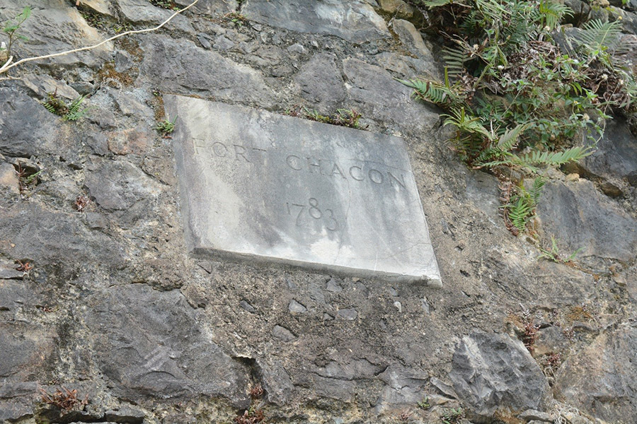
Fort Chacon (Churraca’s Observatory) Port of Spain
Hint: “Observatory St.” Laventille was given its name after this site’s construction.
Hats off to Chacon and Churruca! Photo by Leslie-Ann Paul.
What pray tell are we observing? The stars of course! Now the star-observer in question has a long name; but we’re gonna say it with our chest because we #Respect his talent and endeavours. Don Cosmo Damien Churruca was a Spanish Officer, who was appointed to lead the expedition to fix the longitudinal points in the New World. He successfully linked the New World to the Old world by establishing the absolute longitude of the observatory relative to Cadiz. (Think GPS but without all our satellites and lasers and whatnot). A prolific scientific observer, Governor Chacon gave him permission for the observatory’s establishment, leading to the ground-breaking geographical and astronomical accomplishment.
This was a serious feat in 1792. The observatory itself, which gave an accurate meridian in the New World was dismantled in 1793, but the stone wall upon which it was built still stands.
Catherine’s 2 cents: Seeing some superb works here! Scientific development is always a good direction to take. Three Cheers for Churruca & Chacon, point for the Spanish! Though the building is not an active way to secure one’s colony, the impact it would have made on improving the accuracy of navigation is important.
Fort Picton / St. David’s Tower, Laventille Hills
Hint: Picton’s Folly.

Inside the Tower. Photo by Leslie-Ann Paul.
Picton copied the design of the garrison at Cape Mortella in Corsica when designing this fort. On the ridge of the Laventille Hills, this Martello Tower is forty feet tall. Characterized by a 6ft thick, cannon proof northwest facing wall, The Tower is built of stone and baked bricks. Everything was strategic and specifically placed at Fort Picton. The store rooms, magazine and water supply were on the ground floor, the first level houses the living quarters for the garrison, and the guns are on the top level. Wanting to be prepared for a ground attack, the 6ft wall would limit damage and placing the entrance on the eastern side allowed it to be defended from any angle. Now at the very top of the Tower an 18-pounder and a 6pounder cannon were mounted on a rampart to fire over the parapet (and not through openings as was the typical way of doing it). This Fort is also called Picton’s Folly because the cannons face inward, pointing at the land, when cannons should face the enemy coming from the sea. Further, (the Folly continues) because the fort was placed too far uphill, it could not defend the capital.
Catherine’s 2 cents: *facepalm* He started off strong but I ended up very disappointed. I was on board with Picton trying to be prepared for a ground assault- yes we want be ready for anything. But cannon placement is Military Tactics 101, Sir. Picton got so many things right: sound location because it provides a great vantage point; structure well laid out and thought out- until it was time to set the cannons and ability to effectively defend the capital and he just failed.
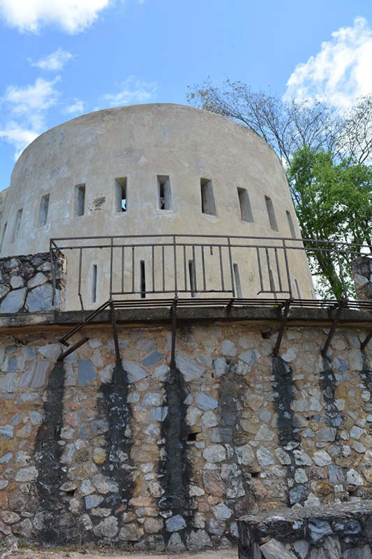
Tower is an understatement. What a formidable structure! Photo by Leslie-Ann Paul
Fort George, St. James
Hint: a fortification that never saw a war.
Also known as La Vigie, this fort was started in 1804 under Brigadier-General Governor Thomas Hislop and built with enslaved labour. It was part of a series of batteries along the northern ‘coastal’ positions (or over-looking the northern coastline) of the Island. Since this was on a hill, it was indeed a lookout, to warn the British of impending attack, which could come from the pesky French battle fleets that lurked in Caribbean waters (Besson, 2011). Hislop placed 12 cannons at Fort George, 4 at Fort Picton, 7 at Fort Abercromby, 2 in Macqueripe. (Besson 2011). After 1846, this fort was no longer a military establishment. However, a signal station was built around 1833 and operated for over 130 years. Designed by Ahsantee Prince Kofi Nti, the signal station ceased its operations in 1964 soon after Independence.
Catherine’s 2 cents:’ Vigie’ translated to lookout in French. I am amused that a British building had a French name- typical Trinidadian stylings! Please take special note of the African contribution to our built heritage, it should not go unnoticed.

Gorgeously maintained. Photo by Satis Phillip
*drum roll please*
The #TT_History_Bus proudly brings to you, a Bonus Fort! This is on the North Coast and not in POS. It’s close by though, so here’s one more #Fort for you. ?
Fort Abercromby, La Filette Beach
Hint: a picturesque hike at Las Cuevas will take you to the remnants of this fortress.
It is 1804, so we’ve been a British colony for about 7 years. However, the British being in charge could change at any moment- or at least the fear of this happening was palpable. For context- this is the year of the Haitian revolution, a whole 13 years of bloody wars, which led to the enslaved (African) people of Haiti successfully establishing themselves as being free from their French overlords. So the risk of a takeover by external colonial forces and internal civilian strife was real. How do you prepare for these potential threats? By building a fort of course. Unlike the others, Fort Abercromby was specifically constructed to be a supply point (if they were forced out of Port of Spain) and as an exit point (in case an evacuation became necessary). We’re talking a
“ last stand” type of fort, if the need ever arose for the British forces to retreat and regroup until help could come via sea. The remains of this fort are two cannons (of the original seven) and the fort wall.
Catherine’s 2 cents: very sensible decision. This was one of the many fortifications that Governor Hislop was responsible for, and I’d like to give him props for a military defence plan that was quite well thought through.

Retaining wall and cannons. Special thanks to RoamTT for this photo!
After reading this, are you wondering, “What’s up with these places now? Can I visit?”
Well The Health Protocols that are in place due to the Pandemic (ugh, go away COVID-19!) have made some of these off limits for the time being. Head to the Ministry of Tourism’s website to see updates on re-openings for Fort George and Fort San Andres. The Trust website will let you know about visiting Fort Chacon and Fort Picton. In the case of Fort Abercromby, please go with professional hikers as the terrain is not for newbies. You’ve been armed with new knowledge. Go #Fortify a friend by sharing this Blog!
Sources
Besson, Gerard. “Articles of Capitulation.” The Caribbean History Archives. Paria Publishing, Port of Spain, Port of Spain. 2013.
https://caribbeanhistoryarchives.blogspot.com/search/label/Capitulation%20of%20Trinidad
https://caribbeanhistoryarchives.blogspot.com/search?q=fort+georgeBesson, Gerard. “Trinidad in Hislop’s Times.” The Caribbean History Archives. Paria Publishing Port of Spain. 2011
National Trust of Trinidad and Tobago. Heritage Assest Register: Fort George. 2016 https://nationaltrust.tt/location/fort-george/
Ottley. Robert Carlton. The Story of Port of Spain capital of Trinidad West ndies from the earliest times to the present. The University Press, Glasgow. 1962.
Roam TT. Fort Abercromby. https://roamtt.com/fort-abercromby/
[1] A surrender. Spain signs a document that hands over Trinidad to the British. See Sources to read the Articles of Trinidad capitulation.